
|
This article needs a clean-up.
You can help Truck Simulator Wiki by re-organizing parts of the article, checking grammar / spelling, and doing other helpful things to correct the article.
|
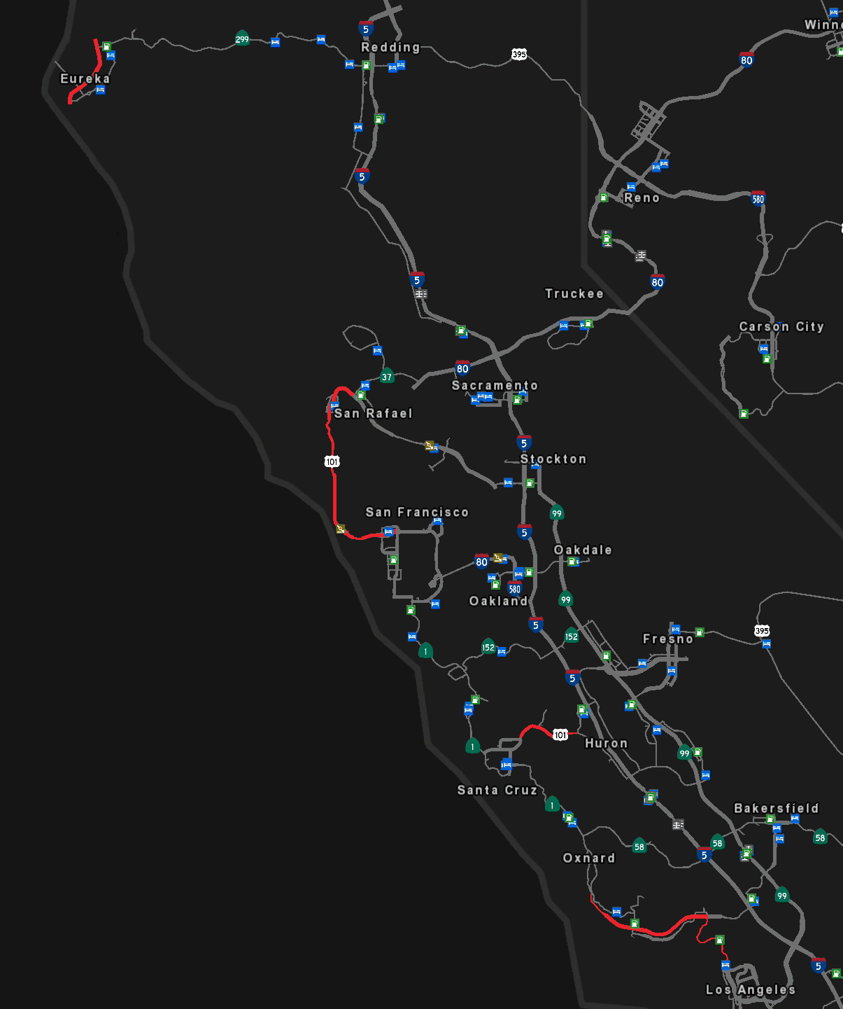
U.S. Route 101 (US 101) is a north–south US Highway in western California, Oregon, and Washington in American Truck Simulator. It runs from Interstate 5 in Los Angeles to Interstate 5 in Olympia. Though the maximum truck speed limit on this route is 60 mph, the car speed limit is 65 mph in some areas of California along the route.
Course[]
US 101 begins at its intersection with Interstate 5 in Los Angeles, CA; in real life this interchange is southeast of Downtown Los Angeles, but in the game it's to the north, in the San Fernando Valley. The highway runs to the north of the Santa Monica Mountains, where CA 27 intersects with the 101. After descending Conejo Grade, the highway enters the Oxnard Plain and the city of Oxnard, and, after crossing the Santa Clara River, intersects with CA 126 in Ventura. Here the highway runs along the coast past Mussel Shoals to Gaviota Pass, a narrow gap in the Santa Ynez Mountains that the northbound lanes crosses with a tunnel. Here the highway begins running inland through the chaparral, where it encounters Santa Maria. After a short coastal run, where it passes Pismo Beach, the 101 meets CA 1, the Pacific Coast Highway, at San Luis Obispo. The highway then begins a long inland route down through the Salinas Valley, where it intersects with CA 58, CA 198, and CA 152, the last at Gilroy. The 101 passes to the east of Santa Cruz, and soon after reaches San Francisco. From Los Angeles to this point the highway has been a freeway, with the exception of an at-grade intersection at a Gallon Oil refinery west of Oxnard, where the speed limit also drops to 30 mph. The highway up until this point has also followed El Camino Real (The Royal Road), a trail first blazed in 1769 to link missions in what was then part of the Spanish Empire.
US 101 runs through San Francisco on surface roads, where it meets the western terminus of Interstate 80, before returning to its freeway routing. The 101 crosses the Golden Gate via the famous Golden Gate Bridge, a 1.7 mile (2.7 km) long suspension bridge built in 1937. This bridge, considered one of the Wonders of the Modern World, is one of the most iconic landmarks in all of California, and is no doubt the most iconic in San Francisco. After crossing the straits, the highway passes through the Robin Williams Tunnel and descends to San Rafael, where it intersects with Interstate 580 at its eastern terminus. The highway then enters the forests of the Northern California Coast Ranges, which it runs through to Ukiah.
Out of Ukiah the highway narrows to two lanes, soon passing through Laytonville, which is located between two rest areas. Past Laytonville the highway winds along the South Fork Eel River, a scenic route that includes landmarks such as the World Famous Tree House, a house carved into a coast redwood; Richardson Grove, an area of massive redwoods that grow close to the road; and Legend of Bigfoot, a tourist-based wood carving shop. Out of the redwoods, the highway returns to a four lane width, continuing along the South Fork Eel on a route with several high bridges. The highway crosses the Eel via two bridges near Rio Dell, and soon after enters Eureka. Out of Eureka the highway intersects with CA 299 and, returning to two lanes, begins its famous and scenic run along the rugged Pacific coast. After a southbound weigh station, the highway rounds Big Lagoon and passes Elk Country RV Resort. At Freshwater Lagoon the highway passes near Redwood State and National Parks, and after curving inland passes the Trees of Mystery tourist attraction, which offers a rest stop. Returning to the coast, the highway runs through Crescent City, and after intersecting with US 199 continues into Oregon, where southbound travelers must stop into an agricultural inspection station just south of the state line.
In Oregon, US 101 is known as the Oregon Coast Highway, and it is this stretch that features some of the highway's best scenery. After crossing the state line, the highway runs along the edge of the Siskiyou Mountains (a sub-range of the Klamath Mountains) past Sisters Rock, a massive sea stack (large offshore rock formation) that can be viewed from two overlooks, the southern one including a rest stop. The highway soon runs through Coos Bay, leaving town via the McCollough Memorial Bridge, a long through truss. The highway then runs through a tunnel before crossing the Cape Creek Bridge, from which the Heceta Head Lighthouse can be seen, and soon after passes by the falls of Cook Creek and Thor's Well, one of the Oregon Coast's many curious features. The highway soon reaches Newport, which it enters via the Yaquina Bay Bridge, and intersects with US 20 at its western terminus. Out of Newport the 101 passes by Yaquina Head, which features a rest area, and soon after runs through Pacific City, where Chief Kiawanda Rock, a large sea stack, can be seen offshore. The highway then proceeds through the dense forest to Warrenton, and crosses the New Youngs Bay Bridge (a rather long bridge with a lifting section) into Astoria, where it meets US 30 at its western terminus.
US 101 makes a spiral climb out of Astoria and crosses the high Astoria-Megler Bridge over the wide Columbia River into Washington. After passing below Point Chinook and Fort Columbia, the highway crosses the Naselle River, near where deer are known to cross the highway. Past a northbound weigh station, the highway enters Aberdeen, where, after crossing the Chehalis River, it meets US 12 at its western terminus. After crossing the Hoquiam River via lift bridges and passing through the town of Hoquiam, the 101 passes through a portion of Olympic National Forest, where it curves by Lake Quinault. After crossing the Queets River, the highway returns to the coast, which it runs along for a short distance through Kalaloch before turning back inland to the town of Forks. Past Forks the road turns east, and proceeds along Lake Crescent before moving through Port Angeles. Here the highway runs through farmland, with the Olympic Mountains as a backdrop, before meeting WA 20 at Discovery Bay. There the 101 heads south along the Hood Canal, past WA 8, to Olympia, where it ends in the same way it begins, at an interchange with Interstate 5.
Cities[]
California[]
- Los Angeles
- Oxnard
- Santa Maria
- Santa Cruz
- San Francisco
San Rafael(replaced by a scenery town in the same location in update 1.44)- Ukiah
- Eureka
Oregon[]
Washington[]
Junction list[]
California[]
| Location | mi | km | Exit | Destinations | Facilities | Notes |
|---|---|---|---|---|---|---|
| Los Angeles | 0 | 0 | ---- | South terminus | ||
| 20 | 32 | |||||
| 35 | 56 | ---- | Rest area | |||
| Oxnard | 45 | 72 | ||||
| 53 | 85 | Oxnard City Center | ||||
| 62 | 100 | 66 A | ||||
| 65 | 104 | 66 B | East Main Street – Oxnard | |||
| 82 | 132 | ---- | Rest area, Gallon Oil depot | At-grade junction | ||
| Mussel Shoals | 104 | 167 | Mussel Shoals | Southbound only | ||
| Santa Maria | 144 | 232 | Santa Maria | |||
| 152 | 245 | Santa Maria | ||||
| San Luis Obispo | 179 | 288 | ||||
| 187 | 301 | |||||
| 249 | 401 | |||||
| Gilroy | 313 | 504 | SR 152 east – Fresno | |||
| Santa Cruz | 349 | 562 | ---- | |||
| 386 | 621 | North end of freeway | ||||
| ---- | San Francisco Downtown (Embarcadero) | TOTSO | ||||
| 388 | 624 | ---- | TOTSO | |||
| 397 | 639 | ---- | San Francisco residential area | TOTSO | ||
| 412 | 663 | ---- | San Francisco Downtown (Embarcadero) | TOTSO | ||
| South end of freeway | ||||||
| 417 | 672 | San Francisco residential area | ||||
| Golden Gate | 430 | 692 | ---- | Golden Gate Bridge | Toll southbound only | |
| San Rafael | 451 | |||||
| Novato | 460 A–B | Southbound exit 460 | ||||
| ---- | Rest area | Southbound only | ||||
| North end of freeway | ||||||
| Hopland | ---- | SR 175 east – Lakeport | ||||
| ---- | Road to Mon Coeur vineyard | |||||
| South end of freeway | ||||||
| Ukiah | 548 | Gobbi Street | ||||
| 554 | 891 | North end of freeway | ||||
| 569 | 916 | ---- | Rest area | Southbound only | ||
| Laytonville | 573 | 923 | ---- | Laytonville | ||
| 588 | 947 | ---- | Rest area | Northbound only | ||
| 655 | 1,054 | South end of freeway | ||||
| Eureka | 700 | 1,128 | North end of freeway | |||
| ---- | ||||||
| South end of freeway | ||||||
| Arcata | 712 | 1,147 | 716 | North terminus in base game | ||
| 724 | 1,166 | 725 | Crannell Road | Northbound only | ||
| 732 | 1,178 | 725 | Crannell Road | Southbound only | ||
| 781 | 1,258 | North end of freeway | ||||
| Orick | 763–765 | 1,228–1,231 | ---- | Elk County | ||
| 795 | 1,279 | ---- | Redwood Creek Picnic Area | |||
| Klamath | 806 | 1,297 | ---- | Motel Trees | ||
| 818 | 1,317 | ---- | Rest area | |||
| 821 | 1,322 | ---- | Gas station | |||
| 825 | 1,328 | South end of freeway | ||||
| 794 | Northbound exit and southbound entrance | |||||
| 830 | 1,336 | North end of freeway | ||||
| ---- | ||||||
| 844 | 1,359 | ---- | Border Protection Station | Southbound only | ||
Oregon[]
| Location | mi | km | Destinations | Facilities | Notes |
|---|---|---|---|---|---|
| 873 | 1,406 | Rest area | |||
| 906 | 1,459 | Rest area | |||
| 947 | 1,525 | Gas station | Southbound only | ||
| 950 | 1,529 | Motel | |||
| 952 | 1,533 | Gas station | |||
| 953 | 1,533 | Service shop | |||
| 1,000 | 1,610 | Washburne State Park | |||
| Newport | 1,050–1,056 | 1,690–1,700 | Or. Coast Aquarium | ||
| 1,065 | 1,714 | Yaquina Bay, Historic Bayfront | |||
| 1,071 | 1,724 | Service shop | |||
| 1,072 | 1,725 | Historic Bayfront | |||
| 1,072 | 1,725 | ||||
| 1,074 | 1,729 | Yaquina Head Historic Lighthouse | |||
| Pacific City | 1,089 | 1,752 | Pacific City | ||
| 1,112 | 1,789 | Cape Lookout Viewpoint | |||
| Garibaldi | 1,150 | 1,851 | Garibaldi | ||
| Astoria | 1,180 | 1,899 | Warrenton | ||
| 1,184 | 1,905 | ||||
| 1,184 | 1,906 | North terminus in Oregon DLC TOTSO |
Washington[]
| Location | mi | km | Destinations | Facilities | Notes |
|---|---|---|---|---|---|
| 1,192 | 1,919 | Inaccessible TOTSO | |||
| 1,196–1,206 | 1,925–1,932 | Secret road | South terminus in Washington DLC | ||
| 1,236 | 1,990 | Inaccessible TOTSO | |||
| 1,245 | 2,005 | Weigh station | Northbound only | ||
| 1,250 | 2,013 | Road to Deepgrove harvest site | |||
| Aberdeen | 1,256 | 2,022 | Southbound TOTSO | ||
| 1,256 | 2,022 | Aberdeen | Northbound TOTSO | ||
| 1,256 | 2,023 | Aberdeen | TOTSO | ||
| Hoquiam | 1,256 | 2,023 | Hoquiam | ||
| Kalaloch | 1,312 | 2,112 | Kalaloch | ||
| Forks | 1,335 | 2,149 | Rest area, weigh station | ||
| 1,339 | 2,156 | Gas station | |||
| 1,352 | 2,176 | Inaccessible | |||
| Port Angeles | 1,372 | 2,209 | Service shop | ||
| 1,373 | 2,210 | Eastbound exit and westbound entrance | |||
| 1,374 | 2,213 | TOTSO | |||
| 1,375 | 2,214 | Hotel | |||
| Discovery Bay | 1,397 | 2,249 | |||
| Potlatch | 1,415 | 2,279 | Potlatch | ||
| 1,463 | 2,356 | Northbound only TOTSO | |||
| Olympia | 1,466 | 2,360 | Black Lake Boulevard – West Olympia | ||
| 1,480 | 2,382 | North terminus I-5 exit 104 |
History[]
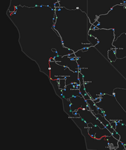
Map of US 101 in the initial version of the game.
- In the initial version of American Truck Simulator, US 101 was separated into four sections. The first section began in Los Angeles as a continuation of SR 110 and headed north along the coast on what is now signed as SR 1. It then merged onto a freeway and continued west until ending in Oxnard where SR 1 would continue north. The second section began where SR 198 currently begins in Huron and headed west until ending at SR 1 in Santa Cruz. The third section began at the north end of the Embarcadero in San Francisco and headed north to San Rafael on the then four-lane Golden Gate Bridge. Where US 101 currently intersects with Interstate 580 and continues north, it turned to the southeast to end at a junction in San Rafael, from which Interstate 580 would continue southeast. The fourth section began at the south end of Eureka and headed north through the town like it currently does and ended at a diamond interchange with SR 299 in Arcata.
- In update 1.3, the section from San Rafael to Eureka was added, along with Ukiah.
- In update 1.5, as part of the 1:35 to 1:20 map rescale, the entire section of US 101 from Oxnard to Santa Cruz was added. The south terminus was changed to a new trumpet interchange with Interstate 5 in Los Angeles. From there, US 101 heads west on the old freeway and reaches Oxnard via a short new section. The coastal section north of Los Angeles was redesignated as SR 1. Between San Rafael and Eureka, new sections were added to the existing highway to accommodate the new map scale. The Golden Gate Bridge was expanded to six lanes.
- In update 1.29, the section from Santa Cruz to San Francisco was added, making US 101 contiguous from Los Angeles to Eureka. Off the exit to SR 152, a gas station and rest area were added.
- In update 1.31, the diamond interchange with SR 299 in Arcata was changed to a trumpet interchange.
- In the initial version of the Oregon map expansion DLC, the section of US 101 from SR 299 in Arcata to US 30 in Astoria was added.
- In update 1.33, a rest area was added by the junction with US 30 in Astoria.
- In the initial version of the Washington map expansion DLC, the section of US 101 from US 30 in Astoria to Interstate 5 in Olympia was added.
- In update 1.41, as part of the first phase of the California rework, the section of US 101 from Ukiah to Eureka was completely reworked. The scenery towns of Laytonville, including rest areas north and south of it, and Rio Dell were added as Leggett and the junction there with SR 1 were removed. A Border Protection Station south of the California–Oregon state line was also added.
- In update 1.44, as part of the second phase of the California rework, the sections of US 101 from San Rafael to Ukiah and through Eureka to Arcata were completely reworked, including a complete rework of Eureka and Ukiah. San Rafael was completely reworked and replaced by a scenery town in the same location. All junctions were rebuilt, and the scenery towns of Hopland, Novato, and Petaluma, including the rest area north of it, were added.
Gallery[]
")
")
")
")
")
")
")
")
")
")
")
")
")
")
")
")
")
")
")
")
")
")
")
")
")
")
")
")
")
")
")
")
")
")
")
")
")
")
See also[]
| Cities | Bakersfield - Barstow - Carlsbad - El Centro - Eureka - Fresno - Hilt - Huron - Los Angeles (Santa Monica) - Modesto - Oakland (Richmond) - Oxnard - Redding - Sacramento - San Diego - San Francisco - San Jose - Santa Cruz - Santa Maria - Stockton - Truckee - Ukiah List of scenery towns in California |
|---|---|
| Highways | Interstate 5 - Interstate 8 - Interstate 10 - Interstate 15 - Interstate 40 - Interstate 80 - Interstate 580 US 6 - US 50 - US 95 - US 97 - US 101 - US 199 - US 395 SR 1 - SR 3 - SR 4 - SR 14 - SR 16 - SR 27 - SR 36 - SR 37 - SR 44 - SR 58 - SR 74 - SR 89 - SR 99 - SR 110 - SR 111 - SR 120 - SR 121 - SR 126 - SR 130 - SR 139 - SR 152 - SR 180 - SR 190 - SR 198 - SR 255 - SR 273 - SR 299 |
| See also | List of landmarks in California - List of Truck Stops in California |
| Cities | Astoria (Warrenton) - Bend (Terrebonne) - Burns - Coos Bay (North Bend) - Eugene (Springfield) - Klamath Falls - Lakeview - Medford - Newport (Toledo) - Ontario - Pendleton (Rieth) - Portland (Troutdale) - Salem - The Dalles |
|---|---|
| Highways | Interstate 5 - Interstate 82 - Interstate 84 - Interstate 105 - Interstate 205 - Interstate 405 US 20 - US 26 - US 30 - US 95 - US 97 - US 101 - US 197 - US 199 - US 395 OR 22 - OR 39 - OR 58 - OR 62 - OR 78 - OR 99 - OR 126 - OR 140 - OR 201 - OR 213 - OR 569 |
| See also | List of landmarks in Oregon - List of Truck Stops in Oregon |
| Cities | Aberdeen - Bellingham - Colville - Everett - Grand Coulee - Kennewick (Pasco) - Longview - Olympia - Omak (Okanogan) - Port Angeles - Seattle (Renton) - Spokane - Tacoma - Vancouver - Wenatchee (Sunnyslope) - Yakima (Union Gap) |
|---|---|
| Highways | Interstate 5 - Interstate 82 - Interstate 90 - Interstate 182 - Interstate 205 - Interstate 405 US 2 - US 12 - US 97 - US 101 - US 395 - US 730 SR 8 - SR 14 - SR 20 - SR 155 - SR 261 - SR 285 - SR 397 - SR 432 - SR 433 - SR 526 - SR 529 - SR 900 |
| See also | List of landmarks in Washington - List of Truck Stops in Washington |